Stan Holroyd recently sent a message to the Wainwright Facebook site in which he mentioned the Scouter magazine. I replied to say that I had written an article that was published in that magazine in 1960, and here it is:
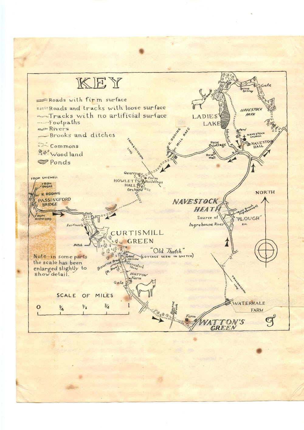
Here are an article and map that I submitted to the Essex Countryside magazine in 1961, but which was never published:
A Ramble through Curtismill Green and above the Ladies’ Lake
It is only very rarely in Essex that one comes across a village that has remained virtually unchanged for hundreds of years, but such a village is Curtismill Green. Each of its cottages is a short walk from its neighbour, and is separated from it by common land, of which there is all too little in the county. The only means of communication is by rough tracks across the heath and through the woodland. The district is very rich in wild life, and a number of deer roam the woods. Deer may also be seen in the region of the Ladies’ Lake.
Yet Curtismill Green is only five miles from Romford, and within easy reach of the populated parts of South-West Essex.The route described below, which is 10½ miles long altogether, passes through only parts of the hamlet. The village green extends westwards towards Stapleford Abbotts Church. In the eighteenth century Curtismill Green was attached to Hainault Forest. It is suggested that the route may be most easily followed if the text is used in conjunction with the map and if walkers keep a few lines ahead with their reading all the time.
* * *
Alight from the no. 250 or no. 175 bus at Passingford Bridge and look for a drive, lined with oak trees, which leaves the main road just south of the bridge by a green triangle. Follow this drive for about three quarters of a mile to the gate into Curtismill Green, where the road forks into three. Take the central lane, approximately straight on. Those with cars are advised to leave them in this vicinity.
After a hundred yards there is another junction. Continue straight on along a rough track following the right hand edge of the common. As soon as the track is met by woodland on the left, shortly after a small stream is crossed, turn sharp left down a grassy ride. Ignore two rides which meet simultaneously on the right, and take the next right turn into the wood.
At the top of the hill the glade leads to a pair of isolated cottages. About fifty yards before the cottages are reached a narrow footpath to the right should be taken. Turn left just before reaching a neatly trimmed hedge, and continue just to the right of two oak trees close together. Do not turn right between the hedges, but keep straight on, passing a dismal pool on the right. This is a dip-hole, 20 feet deep, and supplies water to the cottagers. The path comes out between a charming thatched cottage called ‘Old Thatch’ and a pond (seen in Mr. Wiebkin’s illustration).
(A slight detour here is well worth while to visit the Navestock Stone. Keep straight on across the green, passing between a modern house and the buildings of Rest Harrow Farm. Turn left immediately before a gate across the track, and the stone and its inscription are to be found on the right, beyond a hedge which bends sharply right. The Navestock Stone was erected in 1641 to define the boundary of Waltham, or Epping Forest.)
Turn right on the mowed village green, following the bank of the pond, and look out for an archway in the thicket on the left. Where this path comes out turn left, and make your way to a quaint footbridge over the Bourne Brook at the far right hand side of the glade. This brook is the headstream of the River Rom, just below its source. Continue uphill into a wide glade, past a derilict cottage on the left. When a farm called ‘The Harrows’ is reached, bear right into a cinder road through a gate. The Harrows used to be a public house on the old London road, and local legend has it that there were once coach trips from here to Marble Arch for 1/- return.
Just through the gate bear left across the common. Carry straight on, over a gravel road, and, later on, a metalled road, Murthering Lane. This point more or less marks the limit of Curtismill Green. (If the track ahead is blocked, the route may be diverted along the road to the right for a hundred yards, and back to the original ride.) This ride passes through the last remanant of Navestock Common. The River Rom is again crossed, but this time its source is extremely close, and the watercourse is usually dried up.
__________
WATTONS GREEN AND NAVESTOCK HEATH
__________
IGNORE all branches to the left for about half a mile. The track later widens out into a broad glade, and the path moves over to the left of the green to cross a farm drive. Turn left when a metalled road is reached, in the hamlet of Watton’s Green. After about half a mile, turn left again between two houses (opposite Waterhale farm buildings) into a track, which turns into a metalled road, and leads to a junction. Turn left at the junction, and as soon as Navestock Heath comes into view take a track obliquely to the right. Keep bearing left at junctions until the Plough public house is reached. Notice the old horsedrawn plough over one of its windows. This makes a suitable stopping place, as it is near the halfway point of the route.
Follow the drive away from the pub. Bear left at the first junction and bear right at the second. At the bottom of the hill, turn right, and shortly left, uphill. (To shorten the walking distance by 2½ miles, turn left at the bottom of the hill and pick up the route again where it says ‘turn right over Westaff Brook at a T-junction, after passing Navestock Church and Hall on the left.’)
__________
NAVESTOCK PARK
__________
AFTER half a mile two side turnings on the left meet the road at the same point just before a sharp bend right. Follow the second of these turnings along the side of a wood. At the end of the wood a spinney is visible a short distance away with an opening in it. Through this opening is a narrow ride, which should be followed, ignoring side turnings, for three quarters of a mile to a cross-ways recognisable by the fact that the woodland on the left gives way to fields about fifty yards before the junction is reached.
This narrow, semi-circular belt of woodland is all that remains to show the extent of the old Navestock Park, which is now ploughed over. In a rather inaccessible part of Navestock Park lies the Ladies’, or Lady’s Lake, featured in an article in the January, 1960 issue of the Essex Countryside. After turning left at this cross-ways, our route follows the eastern shores of the lake at a distance of a hundred yards. (The lake may be actually visited, however, by carrying straight on at the cross-roads and forking left at a Y-junction immediately afterwards.)
Keep to the track for about a mile, and turn right over Westaff Brook at a T-junction, after passing Navestock Church and Hall on the left. It was by the damming of Westaff Brook that the Ladies’ Lake was constructed The present Navestock Hall is a very attractive sixteenth century building with a long and interesting history. After a mile take a narrow road to the left at the site of Shonks Mill on the River Roding. Where the lane turns left keep straight on, into a gravel drive. Turn left, after half a mile, into the farm buildings of Howletts Hall, and turn right at the end of the buildings. A hundred yards past a sharp bend left take a grassy track to the right. This leads into a footpath, which leads into another grassy ride, which, in turn, leads into a lane. By keeping straight on we arrive back in Curtismill Green. The road to Passingford Bridge is gained by a gate on the right.